A preview for the third and final installment of the Iowa's Wild Weather series.


Iowa's Wild Weather - Storms is the third and final installment of the Iowa's Wild Weather series.
Transcript
In August of 2020, a collection of thunderstorms, packing hurricane-force winds, leveled large portions of landscape across eight Midwestern states. The widespread event set a record for the nation’s most expensive thunderstorm, causing more than $12 billion dollars in damage. Weather forecasters labeled the powerful storm a Derecho.
Sec. Mike Naig, Iowa Department of Agriculture: ”What is so distinct about that storm is frankly, the length of time that it was on the ground. I mean, you're talking from South Dakota to Ohio. You're talking about a swath across the center part of Iowa, basically, the center third of Iowa from river to river saw damage of some kind, not all of it severe, but some damage. And then the intensity of the storm itself, the winds and then how long those winds were present. Those are things that make this really an unprecedented event.”
Described as a hurricane without an eye, the tempest did most of its damage in Iowa, wiping out millions of acres of row crops. According to the Iowa Department of Agriculture, the derecho inflicted damage in more than 60 counties, with 36 experiencing massive levels of destruction. In all, nearly one-quarter of the corn and soybean crops were damaged or destroyed.
Sec. Mike Naig, Iowa Department of Agriculture: “The damage was so significant on some of these farms and you're looking at a crop that was damaged. Where do you even start to? To start to clean up and rebuild? And people just told me, well, we just we just got after it. And people helped and neighbors came and a family came and those are some things that that really stick with me. But and folks relieved that there was their families were safe. And yet knowing that there was a pretty major effort that was still ahead of them to try, to try to recover. And then, of course, as the days went on, then people really started to look at that crop that was in the field and say, what are we going to do? What do we have here and will we have to go harvest? What's that going to look like? And I also remember visiting with with farmers who had then gone about harvesting or attempting to harvest those crops and go in one direction at mile, mile and a half, you know, per hour in the combine, you know, being really hard on equipment in that process and just grinding through a harvest that was just wouldn't end. It took forever.”
Iowa is not alone in dealing with evolving weather patterns and storms pushing wind speeds higher and rainfall amounts to record levels. In December of 2021, a severe line of storms produced an EF4 tornado in Mayfield, Kentucky. The twister was part of a much larger system that stretched over six states. The supercell thunderstorm spawned multiple tornadoes on its eight hour, 350 mile journey through several Mid-Atlantic states. For Glisan, the significance of this storm wasn’t just the system’s severity, but the storm’s timing.
Dr. Justin Glisan, State Climatologist of Iowa: “And eventually what would become a derecho, by no means as devastating as the August 10th show, 63 tornadoes were spawned from that event. We're talking the middle of December. Okay. The largest tornado outbreak for December for the United States in the United States history across Iowa, but also the largest outbreak of tornadoes for the state of Iowa for any month in December. Blows your mind. It still blows my mind thinking about that.”
The conditions needed for storms to spawn multiple tornadoes, coupled with expanding and shifting storm fronts across the country, are among the conditions Glisan and other climatologists have been watching for several years.
Dr. Justin Glisan, State Climatologist of Iowa: “The general summary there is we're seeing more outbreaks of tornadoes as opposed to one off tornado events, tornadic events. We're also seeing some semblance of a shift from the classic tornado alley, which is in Nebraska, Oklahoma, down in Texas, and expands into parts of Iowa. It depends on what your definition of tornado alley is. We're seeing an increase in tornadoes in Dixie Alley. So in the mid-Atlantic states, Kentucky, Tennessee, Alabama, Mississippi.”
Glisan believes that climate change is playing a role in the severe weather trend being experienced by Iowan’s over the past decade. How much climate change may have influenced the conditions that launched the 2020 derecho may not have a simple answer.
Dr. Justin Glisan, State Climatologist of Iowa: “So when we talk about climate change impacting severe weather, winter weather, any kind of weather event that we talk about, we don't use one event to dictate a trend. As a scientist, we need multiple data points that tell us in a direction that we're moving. Warmer atmosphere via physics has to hold more water vapor. So one degree Fahrenheit is basically 4 percent more water vapor in the atmosphere, a warmer atmosphere with more water vapor availability increases instability in the atmosphere, especially during spring. So we've had peer to peer reviewed studies that have shown that the days in which severe weather environments have increased, especially in March, April, May, April, May, June are due to a warmer climate. So definitely there are climate change fingerprints on the larger scale structure of the atmosphere. Now for individual events was the August 10th Derecho supercharged because of climate change? We don't know yet.
Watch More
The weather’s influence on the market may be closing soon, according to Dan Hueber in Market Plus.

Each commodity took a turn as a market leader, according to Dan Hueber in our Market Analysis segment
Mexico cattle imports, lettuce sourcing, Nebraska wildfire and grain markets with Dan Hueber.
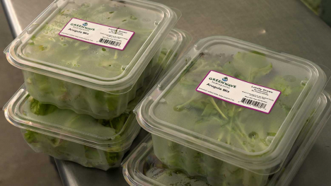
With almost 2,000 cases of Cyclospora attributed to contaminated iceberg lettuce, grocers and consumers are seeking out new sources for salad greens.

USDA outlines inspections and Arizona investments as cattle imports from Mexico prepare to resume.
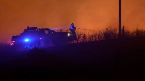
The Morrill Fire burned 643,000 acres as ranchers raced to protect family and livestock.